Though the Romans are famed for their roads along with many other things, they didn’t invent the idea of roads but rather vastly improved upon what had gone before with better engineering, money and manpower to it easier for their vast armies to police the empire and to a lesser extent to enable trade and commerce.
When the Romans arrived in Britain there was already a road system of sorts that dated back thousands of years. What was to be come Roman Watling Street was a broad, grassy trackway that had been used by ancient Britons for centuries.

It stretched from Richborough on the English Channel to a natural ford in the Thames at Thorney Island at what is now Westminster. Today it is hard to imagine Westminster being on an island but that was precisely the attraction why Westminster Abbey was built where it was.
From Thorney Island, the trackway went up to Wroxeter in present day Shropshire where it diverged with one route going westwards towards the NW tip of Wales whilst the other ran up hundreds of miles past Chester and the current Hadrian’s Wall to Pictish Scotland.
The original British and indeed Roman name for the road is unknown and it’s quite possible that the Romans may not have viewed it as a single route at all, dividing it amongst two separate itineraries in one 2nd-century list. The name Watling Street can be derived from the Latin term ‘Via Strata’ which was the designation for any paved roadway and ‘Waeclingas’ or “people of Waecla” who were a tribe who lived just a mile or two away from where I am writing this in the lands around the old city of St. Albans
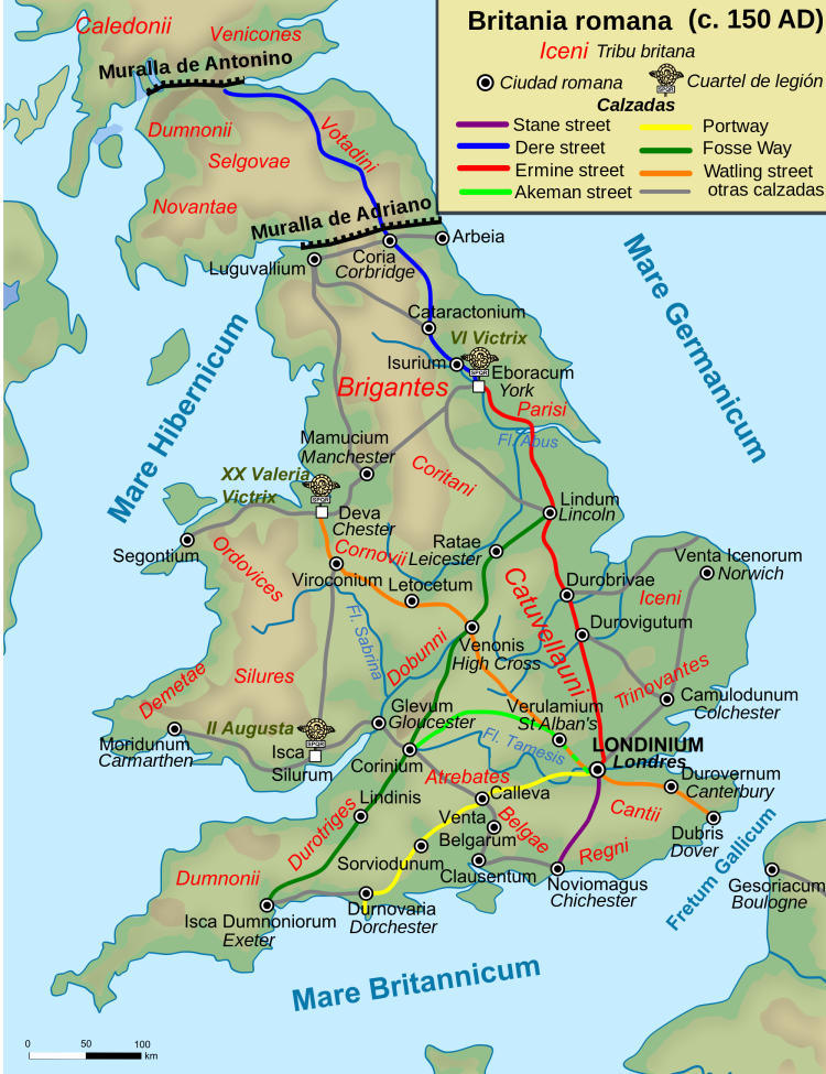
Most traffic in pre Roman times were between the areas of modern Canterbury and St Albans but the Romans later paved the route, which then connected the Kentish ports of Dubris (Dover), Rutupiae (Richborough), Lemanis (Lympne), and Regulbium (Reculver) to their new bridge over the Thames at Londinium (London). The route continued northwest past Verulamium (St Albans) on its way to Viroconium (Wroxeter). The Romans considered the continuation on to Blatobulgium (Birrens) beyond Hadrian’s Wall to be part of the same route, leading some scholars to call this Watling Street as well, although others restrict it to the southern leg as indicated on the map on this post.
The Romans began constructing paved roads shortly after their invasion in 43AD. The London portion of Watling Street was rediscovered during Christopher Wren’s rebuilding of St Mary-le-Bow in 1671–73, following the Great Fire of London. Modern excavations date its construction to the winter from ad 47 to 48. Around London, it was 7.5–8.7 m (25–29 ft) wide and paved with gravel and it must have looked very impressive compared to its surroundings. It was repeatedly relaid, including at least twice before the sacking of London by Queen Boudica’s troops in 60 or 61AD who famously burned several cities to the ground, including Londoninium with about 70,000 dying in the process. In fact such was the destruction that archealogists use the thick layer of burned charcoal deep under the soil as the most reliable way to date events in ancient London.
The road ran straight from the bridgehead on the Thames to what would become Newgate on the London Wall before passing over Ludgate Hill and the Fleet and dividing into Watling Street and the Devil’s Highway west to Calleva (Silchester). Some of this route is preserved beneath Old Kent Road that to this day runs southeast wards from Southwark (the southern end of London Bridge) and 1,000 years later in the first modern English literature, the pilgrims in Chaucer’s Canterbury Tales would have walked it on their route to Canterbury Cathedral.
Fittingly for the Romans who used their fine roads for military use, it was midway up Watling Street not too far from Chester that was the location of heroic and indeed barbaric Queen Boudica’s defeat by the Romans.
By the time of the Saxon invasions, the Roman bridge across the Thames had presumably fallen into disrepair or been destroyed. The Saxons abandoned the walled Roman site in favour of Lundenwic to its west in modern day Covent Garden, presumably because of its more convenient access to the ford on the Thames by Westminster. They did not return to Lundenburh (the City of London) until forced to do so by the Vikings in the late 9th century. Over time, the graveling and paving itself fell into disrepair, although the road’s course continued to be used in many places as a public right of way. “Watlingestrate” was one of the four roads protected by the king’s peace in the Laws of Edward the Confessor, the last great Anglo-Saxon king.

Watling Street was such an impressive feature of the British Isles that it has been used as a boundary of many historic administrative units, and some of these are still in existence today, either through continuity or the adoption of these as by successor areas. One of the most important as these was the Treaty of Alfred and Guthrum where it is thought that Watling Street was made the SW boundary of the Danelaw (lands conquered by Danish Vikings).
More peacefully, the route remains the boundary between the counties Leicestershire and Warwickshire which may itself be a legacy of the ancient treaty. Additionally Watling Street forms part of the boundary of four London Boroughs in the shape of Harrow, Brent, Camden and Barnet.
In more modern times, the first turnpike trust in England was established over Watling Street northwest of London by an Act of Parliament on 4 March 1707 in order to provide a return on the investment required to once more pave the road. It was what might today be called a Toll Road.
Much of the road is still in use today, apart from a few sections where it has been diverted. The A2 road between Dover and London runs over or parallel to the old path. A section of Watling Street still exists in the City of London close to Mansion House underground station on the route of the original Roman road which traversed the River Thames via the first London Bridge and ran through the City in a straight line from London Bridge to Newgate.

The sections of the road in Central London possess a variety of names, including Edgware Road and Maida Vale. At Blackheath, the Roman road ran along Old Dover Road, turning and running through the area of present-day Greenwich Park to a location perhaps a little north of the current Deptford Bridge. The stretch between London and Shrewsbury (continuing to Holyhead) is known as the A5. Through Milton Keynes, the A5 is diverted onto a new dual carriageway; Watling Street proper remains and forms part of the Milton Keynes grid road system.

A number of Old English names testify to route of Watling Street either by using the name outright as is the case where I live or in related names suchBoughton Street in Kent; Colney Street in Hertfordshire; Fenny Stratford and Stony Stratford in Buckinghamshire; Old Stratford in Northamptonshire; Stretton under Fosse and Stretton Baskerville in Warwickshire.
If you’d like to explore Roman London with me on a fabulous private, guided walking tour then do check out https://stephenliddell.co.uk/ye-olde-england-tours-2/our-tours/london-tours/roman-london-walking-tour/

Reblogged this on sed30's Blog and commented:
Fascinating
LikeLiked by 2 people
Lived in Bricket Wood for a few years and was a keen detectorist .I found many Roman coins and artifacts in the fields around Watling Street.
LikeLiked by 2 people
Oh wow, that must have been lots of fun. I have found a few bits just walking around the park in St. Albans after the rain but mostly bits of pottery or mosaic.
LikeLike
Another nice post (I have just come across your blog which will keep me entertained for a long while I think).
But to my eyes, whilst the arm of the road called Watling Street in the City that was where Bloomberg Arcade now is, does appear to be very close to a line from the Roman bridgehead to Newgate, the alignment of the other arm of Watling Street as mentioned and shown in this post is at about 20deg to that alignment and points towards Ludgate. And indeed the MoL Londinium map I have shows (admittedly as “presumed”) that road going through Ludgate, and the road through Newgate going to the Forum.
One wonders if at first there was a bridgehead-to-Newgate direct route, with a fork going to Ludgate, and then as the city got built up with a grid system developing the alignments would have changed.
By the way – I do hope that one day excavations will confirm that the Shooters Hill Rd / Edgware Rd alignments really did continue to a ford in the Lambeth area as is often suggested, in pre-bridge days it would be the first relatively shallow and tide-free point to ford the river, and even after London Bridge presumably still a handy way for through traffic to avoid having to go through Londinium..
LikeLike
Wonder if this answers your query?
LikeLike
whoops
meant to include this link
LikeLiked by 1 person
Aah Time Team from the olden days when everyone was having a bad hair day. Thanks for the video which as it happens was the first thing to spark my interest as to whether they may have been a Roman crossing in the area. Inevitably, as was often the case with Time Team, there was no evidence found at all – a suspected road from a 1930s excavation was dismissed as garden landscaping or natural gravel, pottery indicated a small settlement on higher ground in the area, and downstream – unsurprisingly – there is a shallower patch of Thames between Thorney Island and the higher ground on the other side.
Mildly entertaining though it was, a man with the authority of a bow tie saying that he believed there was a Roman road and ford in an area where they hadn’t done any excavation at all, because there was once one of the many medieval waterman’s stairs there and the Thames is currently a bit shallower there is just opinion and there is still no evidence.
One hopes one day there will be, but for now we can only look to the Simpsons and Lionel Hutz for a reminder of what is needed:
Judge: Mr Hutz we’ve been in here for four hours; do you have any evidence at all?
Hutz: Well, your honour; we’ve plenty of hearsay and conjecture. Those are kinds of evidence..
:).
LikeLike
Since when has Wroxeter moved from Shropshire to Worcestershire?
Living within walking distance of the route of Watling Street that was improved by Thomas Telford at Ketley, part of modern day Telford, I have also been reading John Higgs ‘history’ of Watling Street.
A trip out to Wroxeter with it’s Roman ruins and re-enactments is a regular activity, and since there is a nearby National Trust estate at Attingham, on the route of the old A5, and also a nearby vineyard, we are blessed with some of the better countryside aspects of the old road.
LikeLiked by 1 person
Ha! I don’t know where the Wroxeter relocation scheme came from, thanks for letting me know. I was fortunate to visit Attingham in 2012 ( https://stephenliddell.co.uk/2012/10/28/all-about-attingham-park-and-croft-castle-too/ ), an unexpected pleasure. Shropshire is one of my favourite counties and I would really like to get back one day soon.
LikeLike
“The name Watling Street can be derived from the Latin term ‘Via Strata’ which was the designation for any paved roadway and ‘Waeclingas’ or “people of Waecla” ..”
…
I’ve heard an alternative theory, which is that the original Brythonic name was ‘Sarn Wyddelan’ – and that it continued through North Wales & Anglesey, towards Ireland (gwyddelig/wyddelig = “Irish”, in modern Welsh).
Annoyingly can’t find where I read this now!
Great article, anyway!
LikeLiked by 1 person
Thanks Ari, I love the possibility of the old Brythonic naming origins. I will have to look it up! Glad you enjoyed the post!
LikeLike
as my surname is whatling i am finding it very interesting looking at the history of watling street, maybe some connection some where in the past, one never knows!
alan.
LikeLiked by 1 person
Yes, maybe 2000 years ago your ancestor lived on the street!
LikeLike